- Details
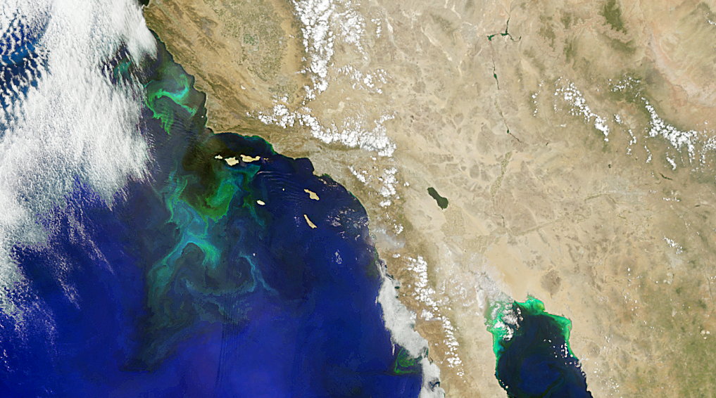
An image of phytoplankton communities off the coast of southern California from the NASA PACE mission.
The story of oceans is the story of life. Oceans define our home planet, covering the majority of Earth’s surface and driving the water cycle that dominates our land and atmosphere. Data collected by NASA’s Earth-observing instruments help scientists understand how Earth’s ocean supports a vast diversity of life and the role it plays in influencing global temperature, weather patterns, climate, and food supply.
This Earth to Sky Virtual Course will explore the story of our oceans. This is a professional development opportunity for place-based interpreters and informal educators.
What is an Earth to Sky Course?
Our workshops provide you with a fantastic opportunity to connect with NASA ocean science, scientists, and data and then synthesize this information with cutting edge science interpretation strategies.
In addition to class time, you will work on your own each week, and meet with your coach in a small group for support. During the course, you will develop an action plan for a science interpretation product or program that you can implement at your home site.
We ask that you bring your own experience, expertise, and ocean story with you. An Earth to Sky course nurtures the robust sharing of ideas, experiences, and aspirations for science interpretation. We invite all of our participants to engage fully in the course and our community of practice.
Details:
- Pre-assignments will take approximately 4 hours to complete.
- This course will be completed over three weeks.
- Registration is free.
- The course will be hosted on Microsoft Teams. An account is not required to participate.
Schedule:
- Course dates: April 21st - May 7th, 2026
- The course will be hosted online via Teams and meet for 2.5 hours every Tuesday and Thursday starting at 5 pm EDT / 2 pm PDT / 11 am HST /7 am ChST. In addition, there will be required small-group and individual off-line work on Wednesday of each week (approximately 1.5-2 hours, start times to be determined by each group).
Apply HERE!
All applicants must register for our community before submitting an application.
Questions or comments can be directed to the course coordinator, This email address is being protected from spambots. You need JavaScript enabled to view it..
We hope to see you online soon!
“How inappropriate to call this planet Earth when it is clearly Ocean” Arthur C. Clarke, Nature 8 March 1990
- Details

When you think about national park and public land astronomy programs, you might picture remote locations far from city lights. But a recent NASA Earth to Sky training, funded by NASA’s Science Activation Program, challenges that assumption, demonstrating how urban parks, wildlife refuges, museums, and green spaces can be incredible venues for connecting communities with space science. Programs facilitated in urban spaces can reach people where they already live, work, and recreate. This creates opportunities for ongoing engagement as urban astronomy program participants can discover that the skies above their neighborhoods hold the same wonders as remote locations.
Learn more about the outcomes of this course in NASA's Science Activation story.
- Details

NASA’s Earth to Sky Idaho Presents:
ADAPT! A Climate Action Workshop for Educators
October 22–24, 2025 | Boise, Idaho
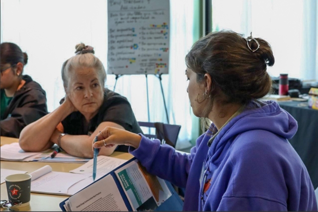
The NASA Earth to Sky Idaho team is hosting its fourth annual climate education workshop—and this year, we’re focusing fully on climate action. Based on feedback from past participants, we’ve designed a hands-on, place-based experience to help educators bring local climate solutions into their teaching.
Over three days, participants will engage in a mix of site visits, pedagogy sessions, and interactive presentations with NASA scientists, local experts, and community leaders. We’ll explore Idaho-specific climate actions grounded in the realities of energy, land use, water, and transportation—using Boise as our living classroom. While site visits will be local, the ideas and strategies are adaptable statewide. Educators from all regions of Idaho are encouraged to apply.
- This free course is hosted by Earth to Sky Idaho in collaboration with NASA, the National Park Service, and the US Fish and Wildlife Service.
- No tuition fee.
- Travel and lodging support available.
What’s Expected
- This workshop will require 4 hours of pre-work which will go toward your 2 PD credits .
- Participants will design a lesson or program that culminates in their audience creating a climate action plan. We’ll provide a flexible template and support you in adapting it to your setting.
- We ask that you join us for all three days of in-person time. The workshop is from 9:00-4:30.
What’s Included
- Funding support to offset the cost of attendance, with stipends for eligible educators. Details collected through the application.
- 2 free PD credits through NNU, BSU, or UofI.
- Food during the workshop.
Who Should Apply?
We’re looking for formal and informal educators and communicators who want to bring climate action to their audiences. Whether you work in a classroom, museum, park, nonprofit, or 4-H club, this workshop is designed to meet you where you are.
Interested in applying? Please complete the application by Wednesday, September 10th.
Download our course flyer here.
Questions? Email our program coordinators at This email address is being protected from spambots. You need JavaScript enabled to view it.
- Details

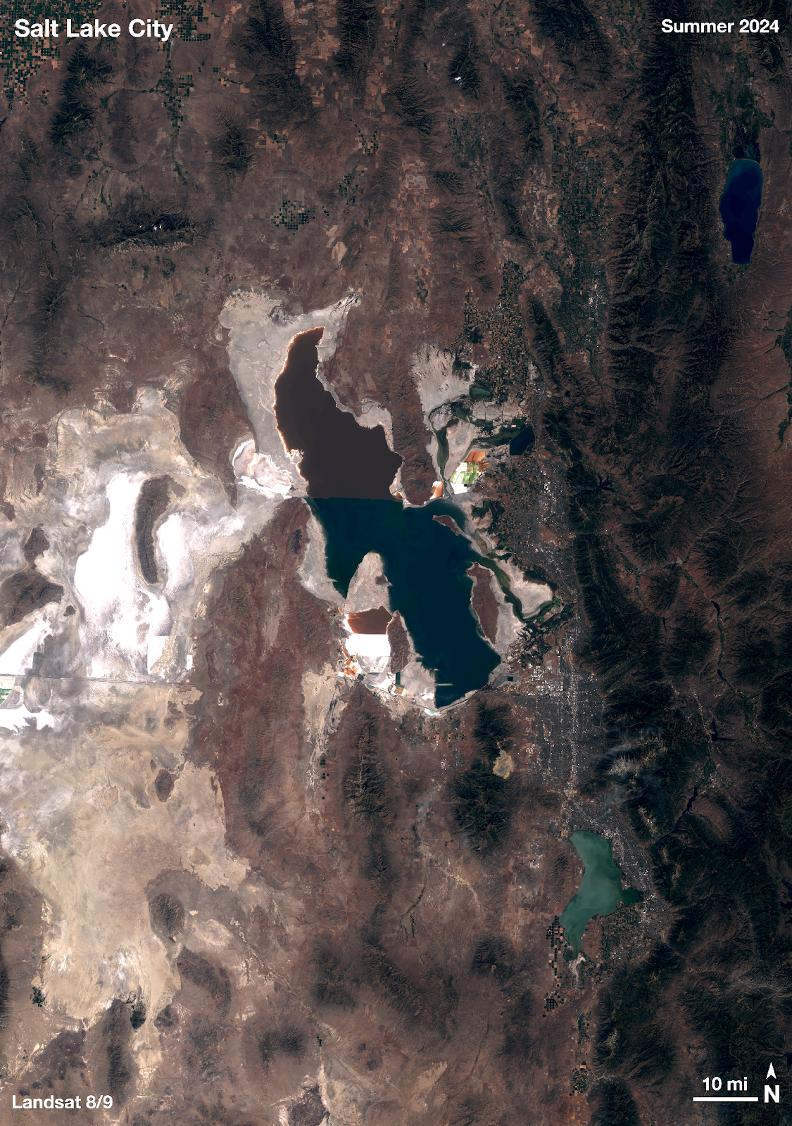
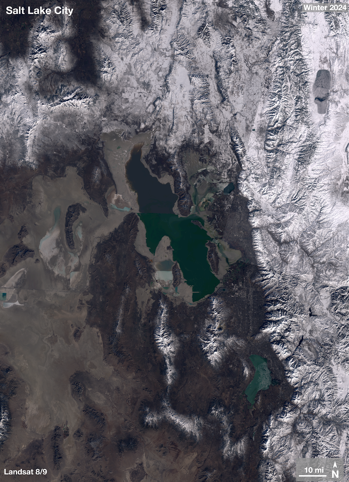
 ETS New Mexico Course, 2023It’s been said that every map contains a story and every good story includes a map. Whether you use Apple Maps, Google Maps, MapQuest, or a good old-fashioned paper map, we can all agree that we’d be lost without them. But maps can do much more than just help you get from point A to point B. Maps can be powerful interpretive programming tools, and NASA makes some incredible maps!
At Earth to Sky, we use maps to connect the wonder of science with the power of place. Recently, our intern Brigitte created this brand-new guide to making natural-color maps from NASA’s Landsat Mission images. Follow the steps below to create your own map or watch the tutorial from our Science in Your Pocket webinar on May 16th, 2025 “A View from Space: Making Your Own Landsat Map”!
Download existing maps on the Earth to Sky Landsat story page.
Software
For this tutorial, you will need two free open-source softwares: Quantum Geographic Information System (QGIS) and GNU Image Manipulation Program (GIMP).
If you or your organization have a license to Photoshop, you can try the Photoshop version of the tutorial.
Workflow
Follow the 5 steps below to create a map of your own. This process will take around 2 hours the first time.
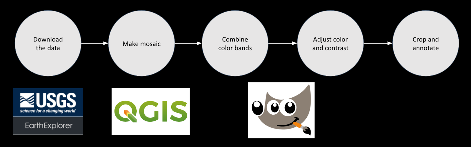
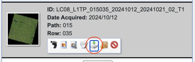
Step 1: Downloading the Data
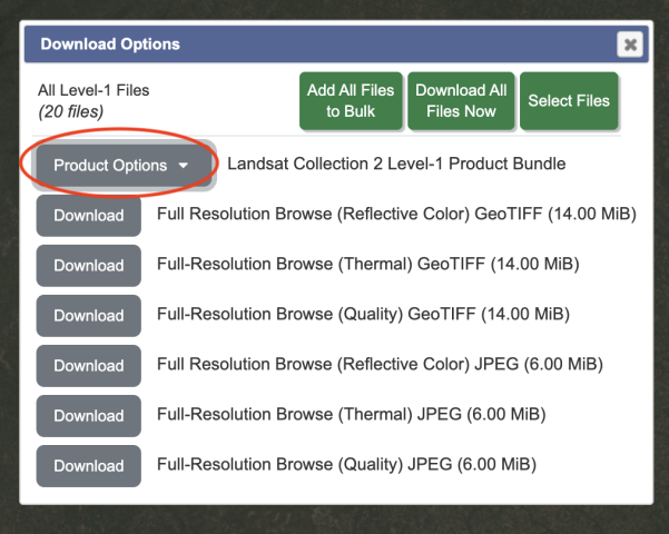
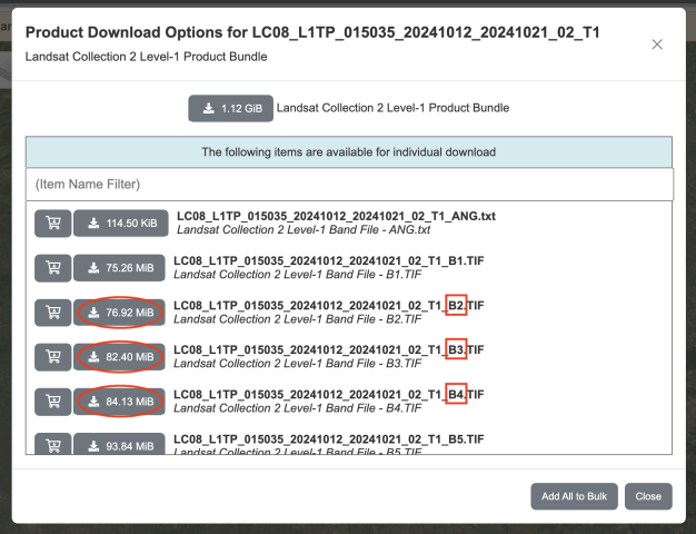
This tutorial will retrieve Landsat data from USGS Earth Explorer. First, you will need to make a free profile and set up your account. After making sure you are logged in, follow “Part 1: Downloading the Data” from NASA Landsat’s Creating a Landsat Image tutorial. In Step 7, after clicking “Product Options,” you can select which individual files rather than the entire package. For natural-color, we want bandcombo B2 (blue) B3, (green), and B4 (red). The files are all GeoTiffs (Tagged Image File Format), which means they include georeferencing data.
Step 2: Mosaicking – QGIS
- Open QGIS
- “New Project” (icon at upper left)
- The goal of this step is to make three mosaics, one for each color. You will do the following steps three times (once for B2, once for B3, once for B4).
-
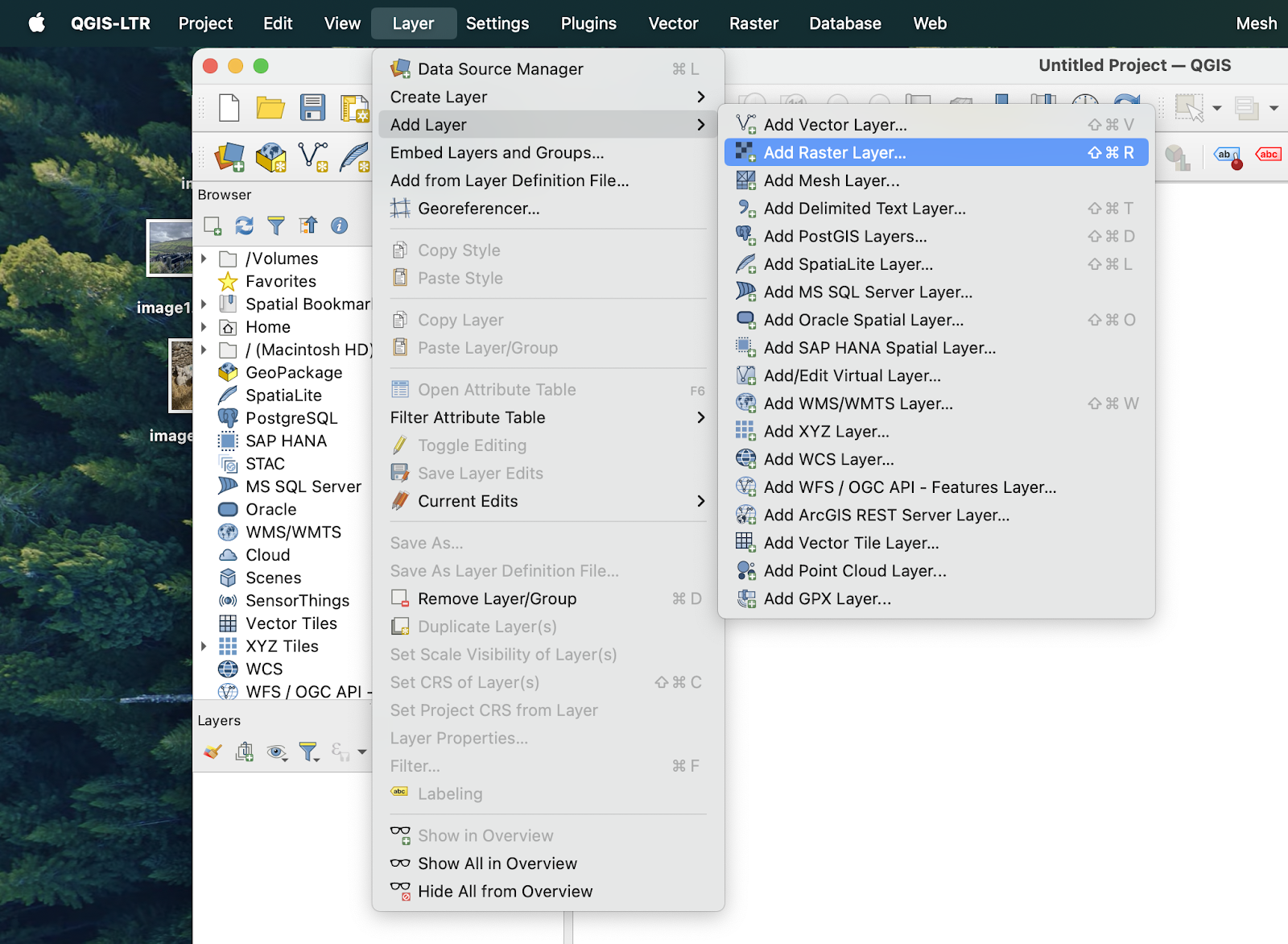
- “Layer” → “Add Layer” → “Add Raster Layer…” → Next to “Raster dataset(s)”, click the “Browser” icon. → select all images (of one bandcombo, i.e. select all B2 tiff) → Click “Add” then once they pop up in the background you may click “Close”
-
- You can reorder the layers front to back by dragging them up or down in the lower left “Layer” panel. If one image has clouds or the seam is very visible, etc. you may be able to cover it up with another image
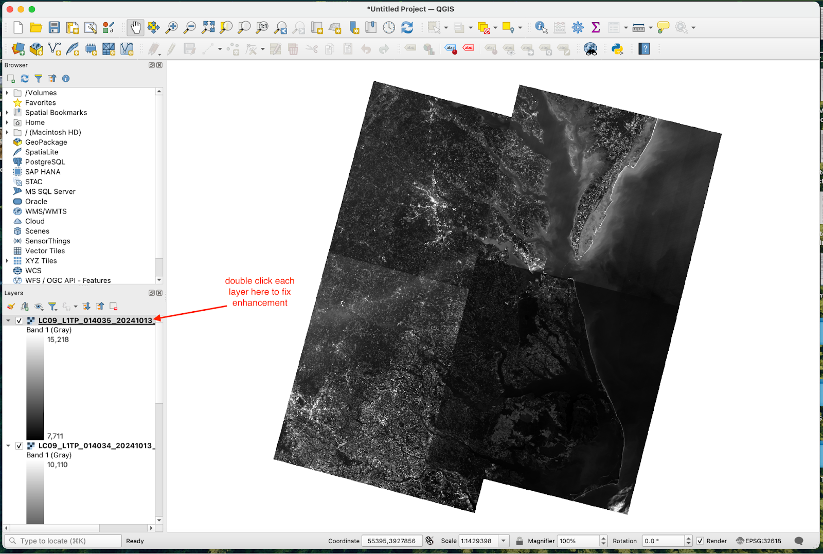
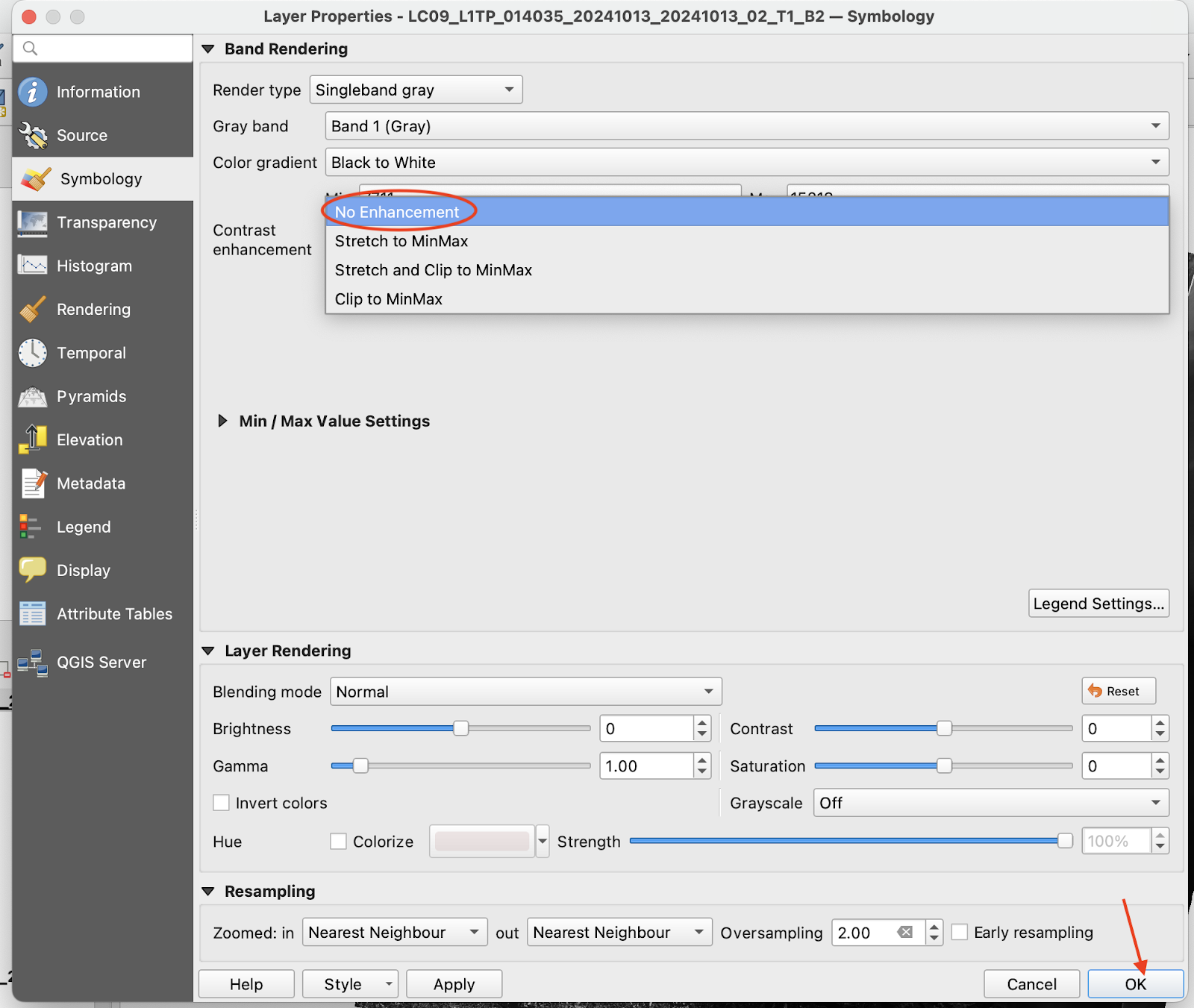
- Double click each file name (in the lower left “Layer” panel) and set “Contrast Enhancement” to “No Enhancement” then click “OK.”
-
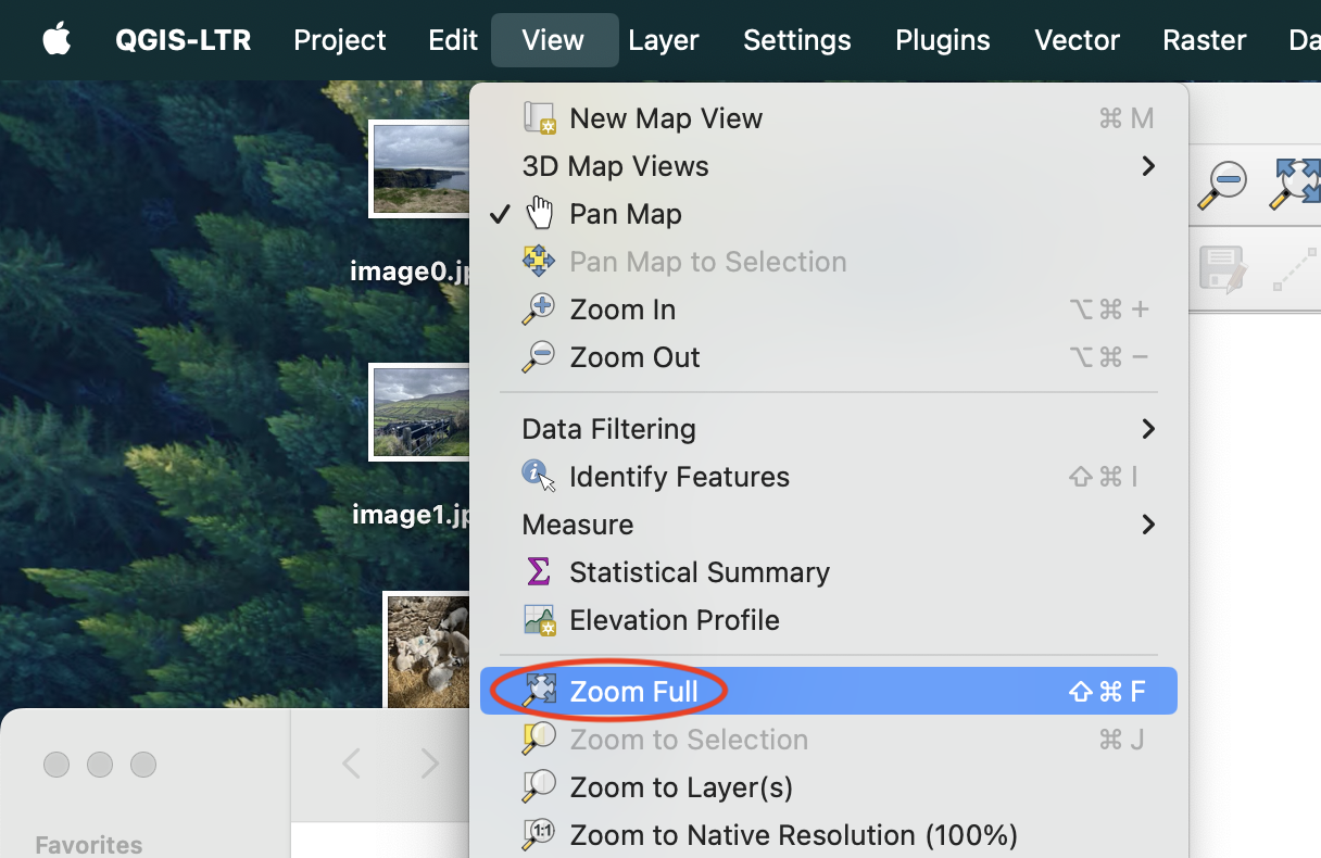
- To get the entire image centered, click “View” → “Zoom Full”. This will ensure all the images are aligned when we open them later on.
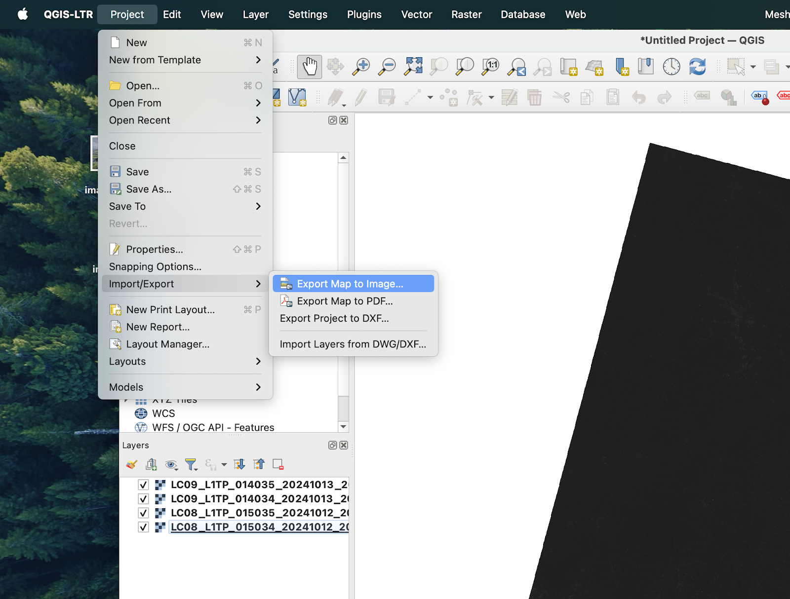
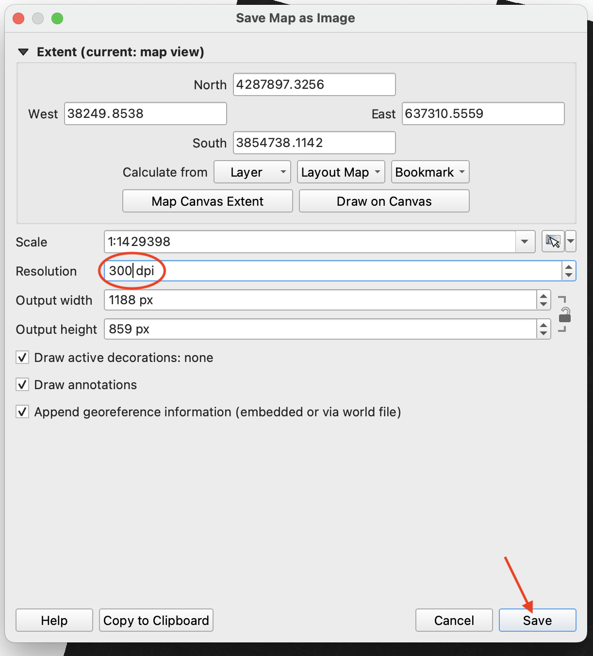
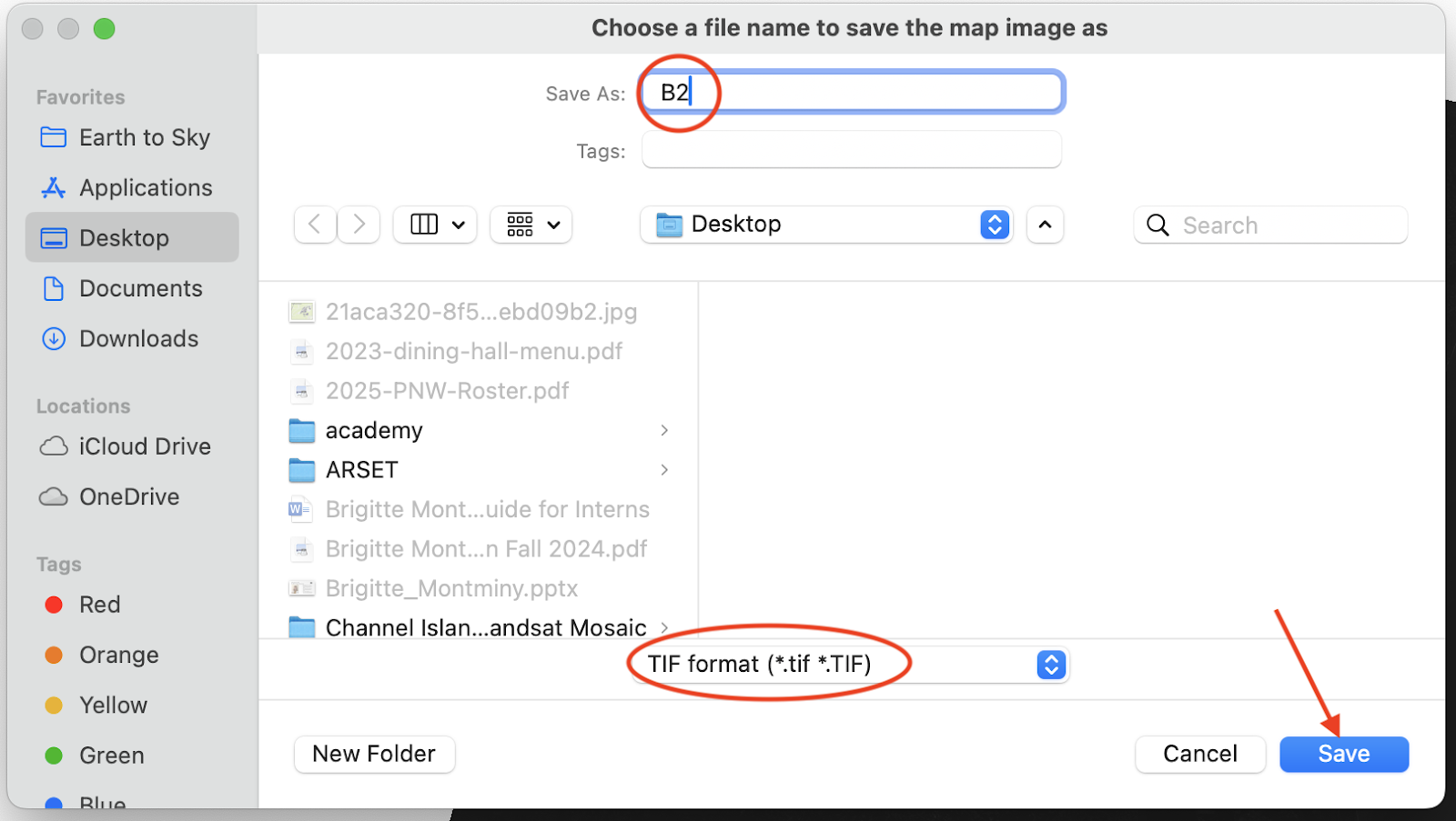
- “Project” → “Import/Export” → “Export Map to Image” → set “Resolution” to 500 dpi → “Save” → name the file (ex. B2), select the location, and select .tif
- The resolution depends on your map area, computer storage capacity, and desired outcome. Feel free to mess around with the resolution a bit.
Now, you should have three mosaics saved as .tif files, one for each bandcombo (B4, B3, B2).
NOTE: QGIS may save xml files into your folder for each individual file. You can ignore these.
Step 3: Merging Channels – GIMP
The goal of this step is to combine the three mosaics you just made into one mosaic that is RGB.
- Open GIMP
- “File” → “Open” → select your B2, B3, and B4 mosaics → “Open” → wait for all three images to load, this may take a moment and there may be other windows to pop up, but they should automatically close)
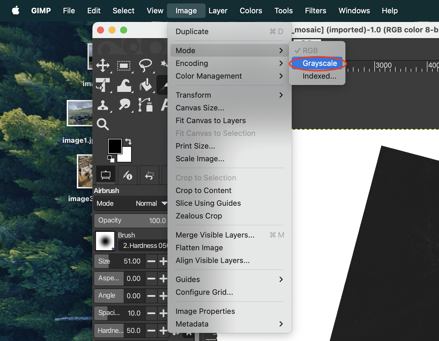
- At the top area, you should see three tabs (one for each of your mosaics). One by one, go to each image (by clicking on it in the tabs) and click “Image” → “Mode” → “Grayscale”. Make sure you do this for all three.
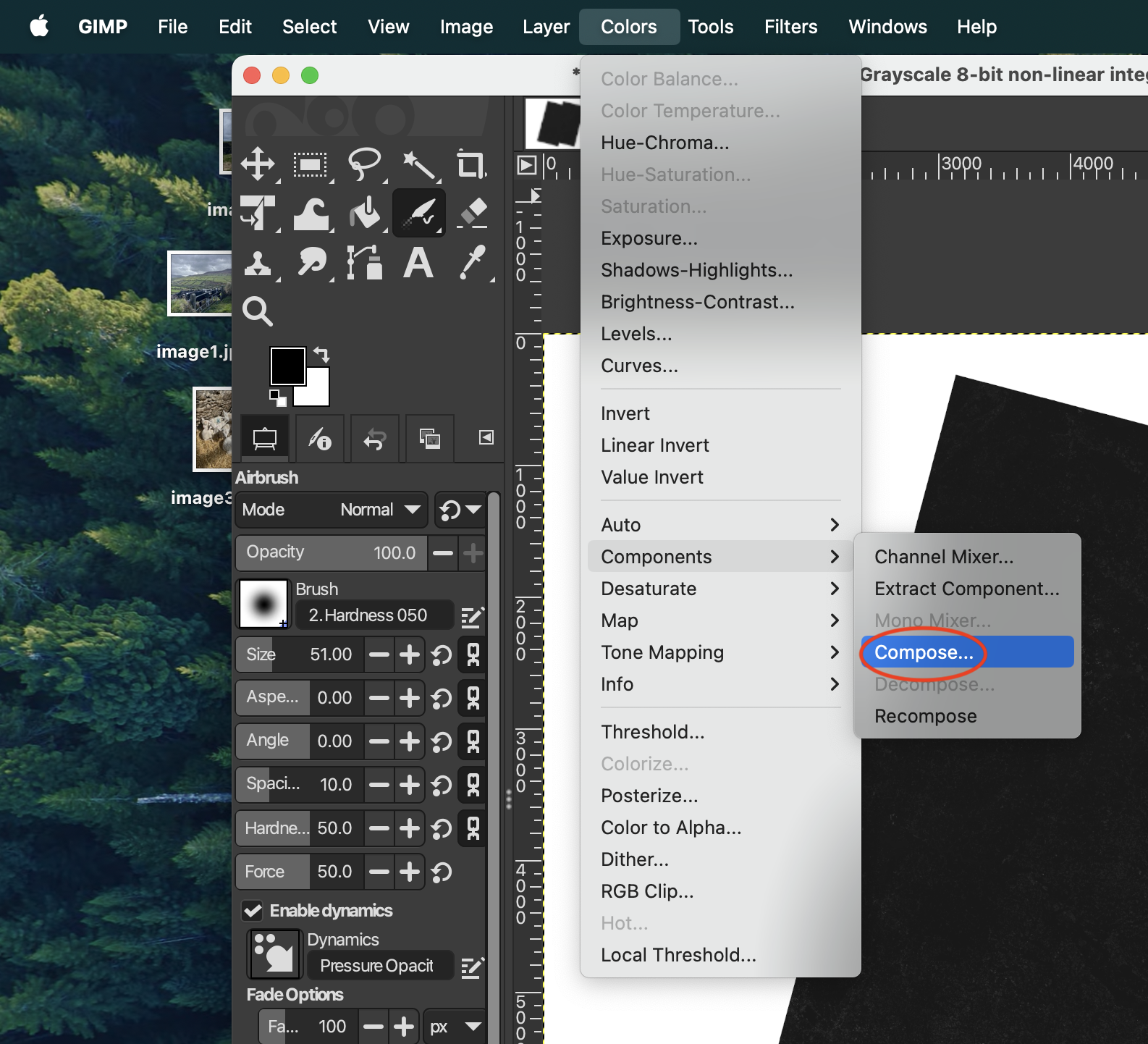
- Now combine the three mosaics into one full-color mosaic.“Colors” → “Components” → “Compose” and wait for a smaller window to pop up.
- Assign each bandcombo mosaic to the color using the dropdown buttons (red is B4, green is B3, blue is B2) → “OK”
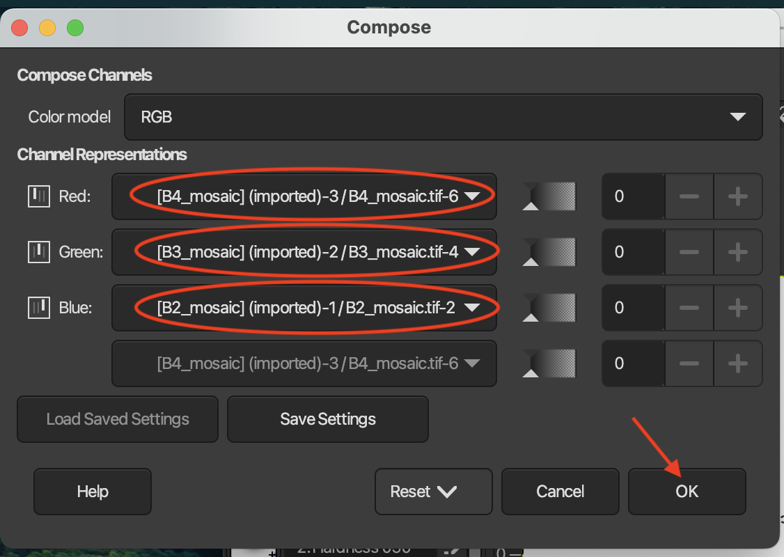
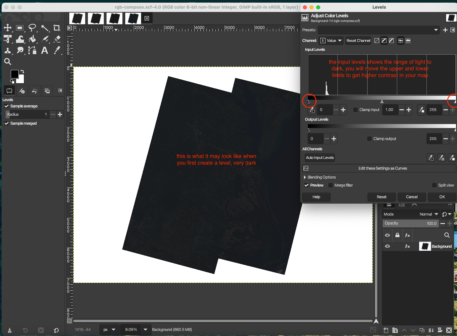
Wait for a new file to open (it will still look all black, should not be bright colors yet)
Step 4: Adjusting Color – GIMP
The goal of this step is to adjust the contrast and colors to create our full natural-color map.
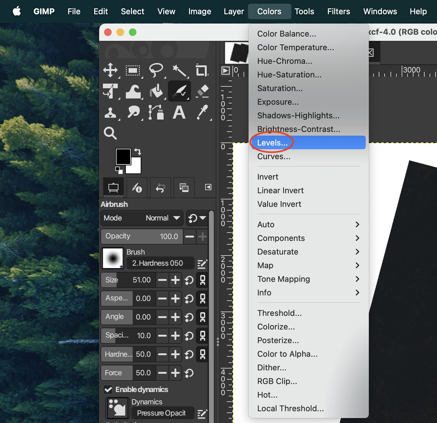
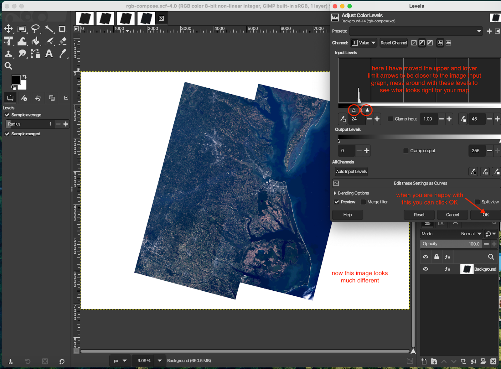
- “Colors” → “Levels…” → The window that pops up will have a graph for the input levels, we want to manually adjust the input level high and lows (light and dark) by moving the arrows right below the “Input Levels” graph (see images below). The goal is to lie on either end of the spikes on the histogram. Mess around with these levels until the contrast on your map allows you to see more details → “OK”
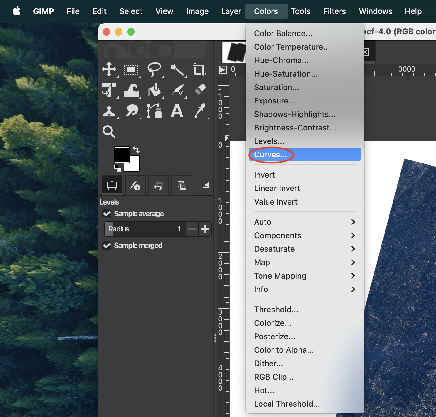
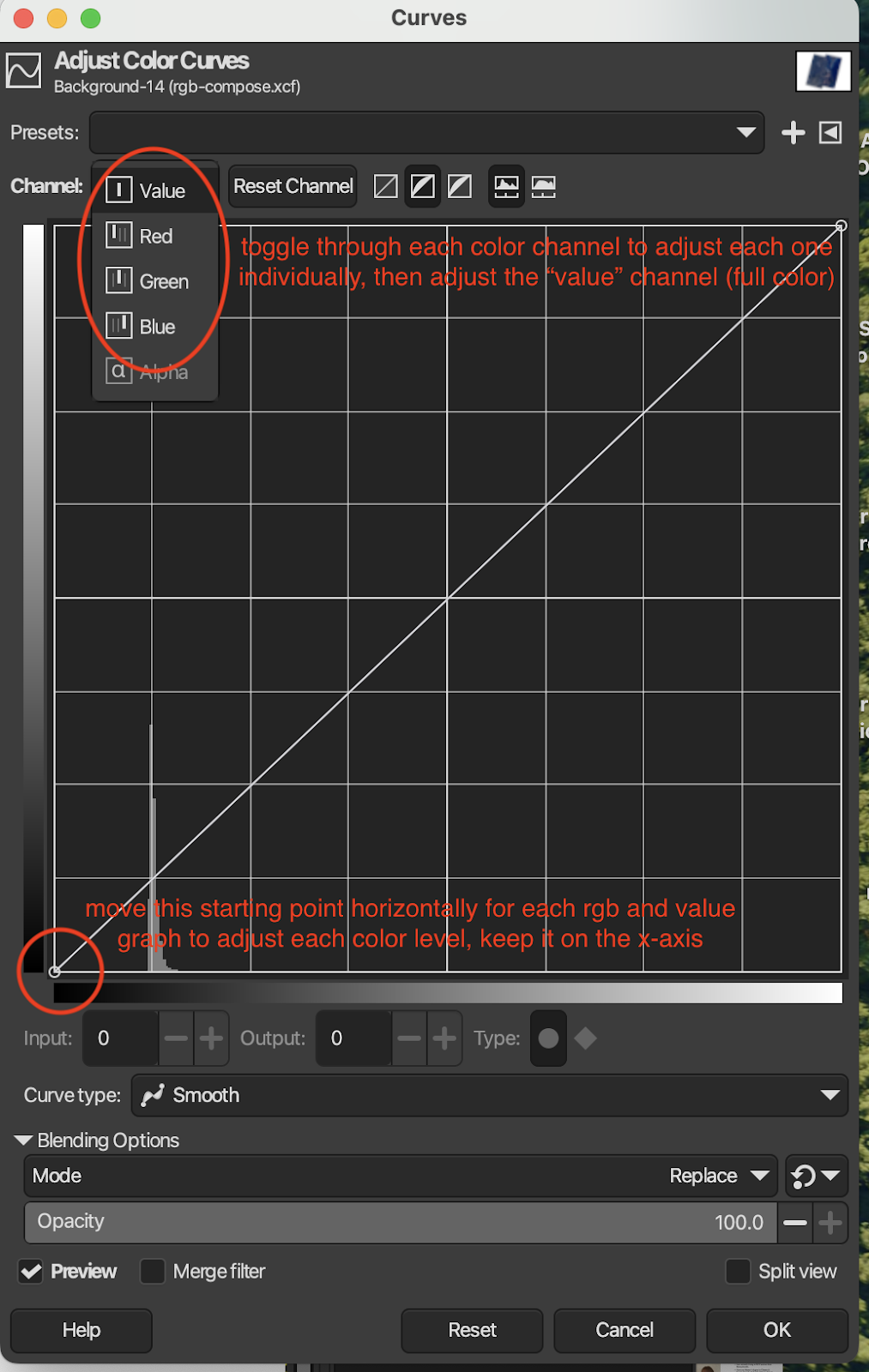
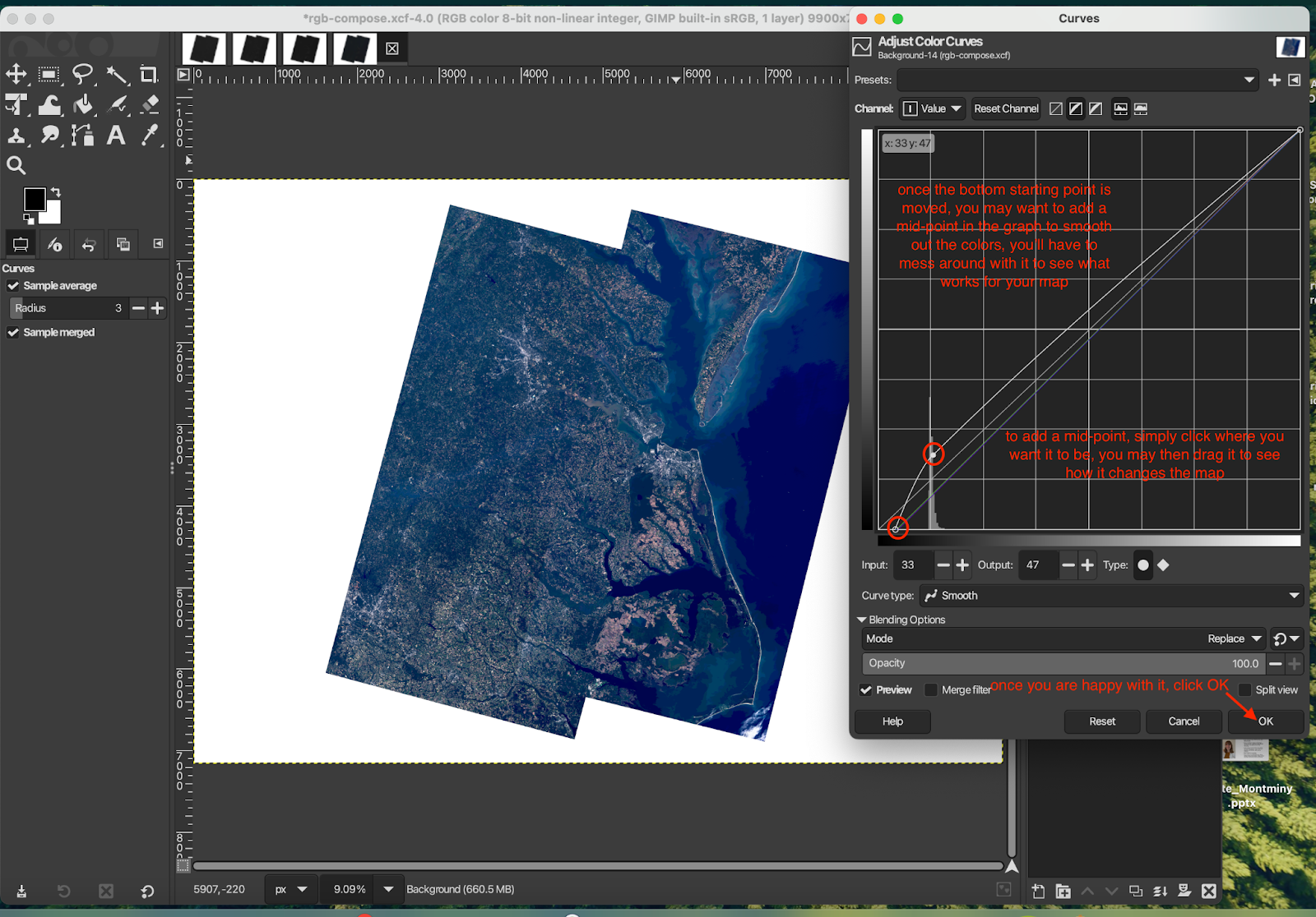
- “Colors” → “Curves…” → A small window will pop up that will allow you to manually adjust rgb curves and the total curve. Adjust the first point of each curve to sit between the start of the graph and the first major histogram spike. You can toggle between each color (red, green, blue, total) with the dropdown menu next to “Channel”. On the “Value” channel, add a point to the histogram to smoothen out the colors by clicking on the histogram. You can move this point up and down to adjust the brightness. Again, mess around with these graphs until you are happy with how your map looks.
- File → Save → this will save your work as a xcf file format
- File → Export → you may choose to save it as a png, jpg, etc.
Step 5: Crop & Add Annotations
Time to finalize your map!
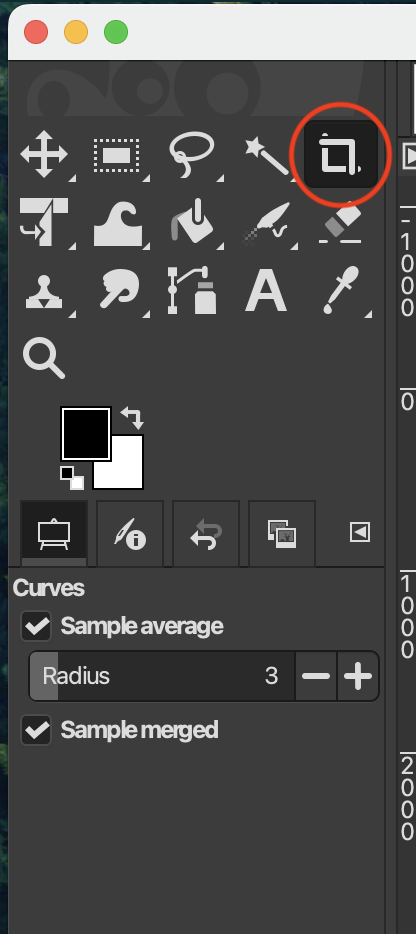
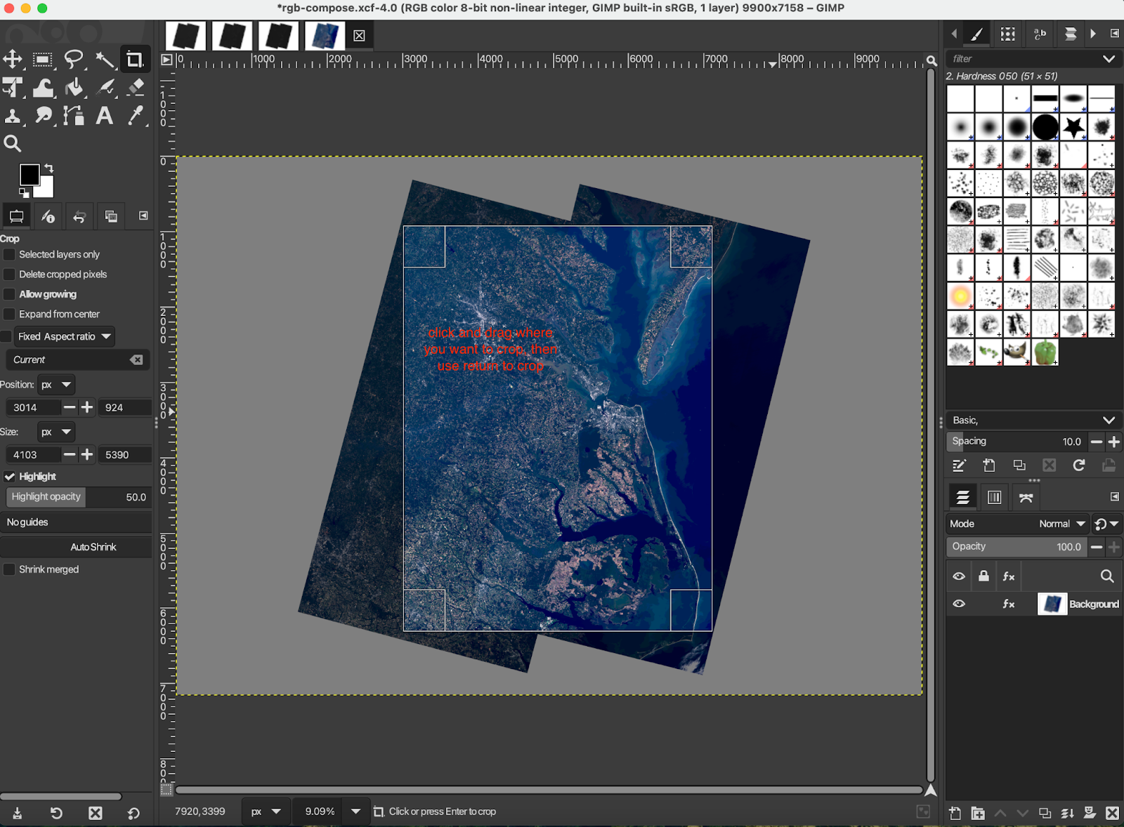
Cropping: select the crop icon in the upper left hand toolkit, then click and drag on your map where you want to crop
Annotations you may want to include:
- Name of your region
- Observing satellite (Landsat 8/9)
- Data acquisition date
- North arrow
- Scale bar
Here's an example!
Made by Brigitte Montminy

Brigitte Montminy was a Climate Interpretation Intern working with Earth to Sky from August 2024 to May 2025. With a Bachelor’s degree in Astrophysics and a Master’s degree in Climate & Society from the Columbia Climate School, she is a science nerd with a specific love for maps. From mapping Jupiter’s polar clouds to Earth’s beauties, Brigitte is a fan of all types of maps. She is also currently working as a Climate Media Specialist at The YEARS Project, putting out a weekly newsletter and action toolkit.
Resources:
-
Earth to Sky Images | Landsat Science → collection of Landsat mosaics made for ETS
-
Creating a Landsat Image Using Photoshop w/ Mike Taylor | ETS Webinar (must be signed in)
-
Storytelling with Satellites - Landsat - Hawaiʻi Island w/ Ginger Butcher | ETS Webinar (must be signed in)
-
Creating a Landsat Image | NASA Landsat Science → great tutorial showing how to make a natural- or false-color Landsat image (note: not for mosaics)
-
Landsat Case Studies 2018 | NASA Landsat Science → learn about some of these tangible benefits of Landsat
-
Band Combination Interactive | NASA Landsat Science → online tool to visualize different Landsat band combinations using five different bands: blue, green, red, near-infrared, and short-wave infrared
-
What are the band designations for the Landsat satellites? | U.S. Geological Survey
-
What is the naming convention for Landsat Collections Level-1 scenes? | U.S. Geological Survey
- Landsat 8 Swath Animation | U.S. Geological Survey
- Details

ETS New Mexico Course, 2023It’s been said that every map contains a story and every good story includes a map. Whether you use Apple Maps, Google Maps, MapQuest, or a good old-fashioned paper map, we can all agree that we’d be lost without them. But maps can do much more than just help you get from point A to point B. Maps can be powerful interpretive programming tools, and NASA makes some incredible maps!
At Earth to Sky, we use maps to connect the wonder of science with the power of place. Recently, our intern Brigitte created this brand-new guide to making natural-color maps from NASA’s Landsat Mission images. Follow the steps below to create your own map or watch the tutorial from our Science in Your Pocket webinar on May 16th, 2025 “A View from Space: Making Your Own Landsat Map”!
Download existing maps on the Earth to Sky Landsat story page.
Software
For this tutorial, you will need Adobe Photoshop. If you or your organization have a license to Photoshop, this is the tutorial for you!
If you do not have access to Photoshop, feel free to check out the other version of this tutorial that uses free, open-source softwares QGIS and GIMP.
Step 1: Downloading the Data
This tutorial will retrieve Landsat data from USGS Earth Explorer. First, you will need to make a free profile and set up your account. After making sure you are logged in, follow “Part 1: Downloading the Data” from NASA Landsat’s Creating a Landsat Image tutorial. In Step 7, after clicking “Product Options,” you can select which individual files rather than the entire package. For natural-color, we want bandcombo B2 (blue) B3, (green), and B4 (red). The files are all GeoTiffs (Tagged Image File Format), which means they include georeferencing data.
Step 2: Merging Channels
- Open Adobe Photoshop
- You will now combine bandcombos for each individual image set. Choose one data set to start with.
- File, Open, select the files for one image set ending with B2.TIF, B3.TIF, and B4.TIF files from the correct folder. (On a Mac, hold the command button to select multiple files. On a PC, use the control button.) Three tabs should be open in the Photoshop window. They will all be in greyscale and will look quite dark.
- While looking at one image (does not matter which of the three), click “Channels” in the lower right module, or use the Window menu to select “Channels.” There will only be one channel labeled “Grey” so far. Now click the hamburger icon (horizontal lines) to the right of the Channels tab. Select “Merge Channels.”
- A pop-up will appear. Change the mode from “Multichannel” to “RGB Color” and leave “Channels: 3.” Select “OK”
- Now you will assign each of the three images to a color band. For making a natural-color mosaic with Landsat 8/9 images, the bands 2, 3, and 4 correspond to colors Blue, Green, and Red respectively. See above for more detailed background on this. Click the dropdown next to “Red” and select the B4 file. Select the B3 file for blue and the B2 file for red. Click “OK”
- The pop-up will disappear and you will be left with just one tab of one combined image. Save this as a tif, naming it after the image set (or path/row, date, etc.) and RGB (ex. “set1_rgb.tif” or “12_31_rgb.tif”)
Repeat this for each set of images you downloaded.
Step 3: Mosaicking
In Photoshop, we will now merge the RGB files into one larger mosaic. Under “File” and “Automate” select the “Photomerge” button. Select “Browse” to choose the RGB files from the previous step (i.e. one file for each image set you chose). Leave “Blend Images Together” selected and Layout as “Auto”. Click “OK” and watch the magic happen!
When the process is complete, you will be left with a mosaic of all your images. However, it will still look very dark. You will fix that next.
Step 4: Adjusting Color
Follow “Part 2: Natural-color Image” from the Creating a Landsat Image tutorial. Ignore Step 1 as you’ve already done that!
Step 5: Crop & Add Annotations
Time to finalize your map! Crop to your desired rectangular size.
Annotations you may want to include:
- Name of your region
- Observing satellite (Landsat 8/9)
- Data acquisition date
- North arrow
- Scale bar
- Landsat 8/9 data in bands 2, 3, and 4 have a scale of 1 pixel = 30 meters. Scale this up as you see fit for the scope of your region. For instance, you might look at the scale bar of your region in Google Maps and decide that 10 miles would be a good scale bar. Thus you need a scale bar 536 pixels long (convert 10 miles to meters, then divide by 30). Create a new layer and label it “Scale Bar.” Use the Rectangular Marquee tool to draw a box of any size. Under the Select menu, select “Transform Selection.” In the options area that will appear at the top of the screen, unselect the chain-link between the W (width) and H (height) fields so that you can change each dimension of your box independently. Then enter “536 px” in the W field, and “30 px” in the H field. Select the check mark at right to finalize the changes to your rectangular box. Next, set the foreground color to white, and use the Paint Bucket tool to fill your rectangular selection with white. Use the Move tool to drag your scale bar to the lower right corner. Use the Horizontal Type tool to label your scale bar “10 mi”.
- Try to place your scale bar and labels over areas of your map that have less texture to make them more readable. If that’s not possible, you can add a translucent gray box behind the labels to make them stand out better.
Here's an example!

Made by Brigitte Montminy
Brigitte Montminy was a Climate Interpretation Intern working with Earth to Sky from August 2024 to May 2025. With a Bachelor’s degree in Astrophysics and a Master’s degree in Climate & Society from the Columbia Climate School, she is a science nerd with a specific love for maps. From mapping Jupiter’s polar clouds to Earth’s beauties, Brigitte is a fan of all types of maps. She is also currently working as a Climate Media Specialist at The YEARS Project, putting out a weekly newsletter and action toolkit.
Resources:
-
Earth to Sky Images | Landsat Science → collection of Landsat mosaics made for ETS
-
Creating a Landsat Image Using Photoshop w/ Mike Taylor | ETS Webinar (must be signed in)
-
Storytelling with Satellites - Landsat - Hawaiʻi Island w/ Ginger Butcher | ETS Webinar (must be signed in)
-
Creating a Landsat Image | NASA Landsat Science → great tutorial showing how to make a natural- or false-color Landsat image (note: not for mosaics)
-
Landsat Case Studies 2018 | NASA Landsat Science → learn about some of these tangible benefits of Landsat
-
Band Combination Interactive | NASA Landsat Science → online tool to visualize different Landsat band combinations using five different bands: blue, green, red, near-infrared, and short-wave infrared
-
What are the band designations for the Landsat satellites? | U.S. Geological Survey
-
What is the naming convention for Landsat Collections Level-1 scenes? | U.S. Geological Survey
- Landsat 8 Swath Animation | U.S. Geological Survey
- Details
Tuesday, August 5th-Thursday, August 7th, 2025
Minnesota Valley National Wildlife Refuge
Please Save-the-Date for an upcoming Earth to Sky night sky and space science professional development opportunity for interpreters, communicators, and non-formal educators in the Upper Midwest!
This course is hosted by Earth to Sky (ETS), funded by NASA, and offered in collaboration with the National Park Service and the US Fish and Wildlife Service. Interested in collaborating with the planning team for this course? Please contact Brandi Stewart, ETS Space Science Coordinator, at the contact information below.
About the Course
Join us for a three day workshop tailored for those who want to share the night sky with their audience. This collaborative training will provide nonformal educators and interpreters with tools, resources, and connections to enhance night sky programs. This course is ideal for beginners and seasoned night sky communicators, whether you’re just starting to facilitate stargazing programs or looking to enhance your astronomy interpretation skills. Participants will explore methods for effective space science programming while integrating regional perspectives to deepen audience connection to the night skies.
Through hands-on activities, expert presentations, and collaborative sessions, participants will gain confidence in orienting visitors to the night sky, techniques for astronomy programming without specialized equipment, and strategies for engaging all audiences in urban and rural settings.
You’ll become part of the growing Earth to Sky community of practice of over 2200 communicators and scientists from a variety of organizations that integrate NASA science into their place-based programming. Most importantly, you’ll gain practical resources for your interpretive toolbox and an actionable plan for creating memorable experiences under the stars for your visitors.
Resource Fair Opportunity
During this workshop, we will host a resource fair for participants to engage one-on-one with local resources to enhance their night sky programming. We are looking for organizations that can speak to nocturnal wildlife, dark sky initiatives, light pollution, astronomical photography, amateur telescope hosts, citizen science, or creative arts. Participants are also encouraged to be presenters at the resource fair! If you are interested in learning more, please contact Brandi Stewart.
Target Audience
Frontline interpretive staff, non-formal educators, public lands interns, tour operators, science communicators, and interpretive managers from the private or public sector interested in collaborating with others to communicate about night skies and space science. No prior experience with night sky programming is necessary! We encourage anyone who is interested in astronomy communication to apply!
The application period has closed.
For questions, comments, or concerns, please contact at Brandi Stewart, ETS Space Science Coordinator, at This email address is being protected from spambots. You need JavaScript enabled to view it.
Photo credit: Logan Sauer/USFWS
- Details
Common Ground for Climate Communication: Building Resilience in the Pacific Northwest
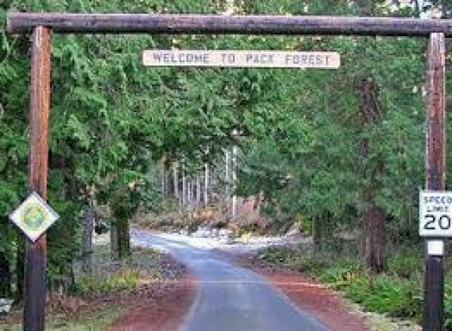
Earth to Sky is coming to Eatonville, WA on March 12-14th, 2025!
This free, in-person, workshop where participants will explore how the Pacific Northwest is fertile ground for world-class climate interpretation and communication.
This course is hosted by Earth to Sky, funded by NASA, and offered in partnership with the National Park Service, the U.S. Fish and Wildlife Service, the Washington State Climate Office and the University of Washington.
About the Course
The dynamic natural and cultural landscape of the Pacific Northwest provides a rich backdrop for
 place-based interpreters to foster awareness, inspire hope, empower resilience, and communicate timely solutions to address climate change. This course seeks to nourish a community of practice that enhances the region’s capacity to access and share NASA climate science with its visitors. Participants will leave this course equipped with knowledge about cutting-edge climate science and a plan for bringing the climate story to their visitors in engaging and inspiring ways.
- Join interactive sessions with experts on topics from the natural and social sciences.
- Connect with colleagues at the beautiful Pack Forest site.
- Get on the front lines with a field trip to a local site.
- Travel and lodging support are available.
Target Audience
Interpretive managers, interpreters, tour operators, informal educators, and science communicators at federal, state or municipal agencies, non-profit and private organizations. Knowledge of climate science is not required.
For more information, check back here, join our mailing list by emailing This email address is being protected from spambots. You need JavaScript enabled to view it. or contact This email address is being protected from spambots. You need JavaScript enabled to view it..
- Details
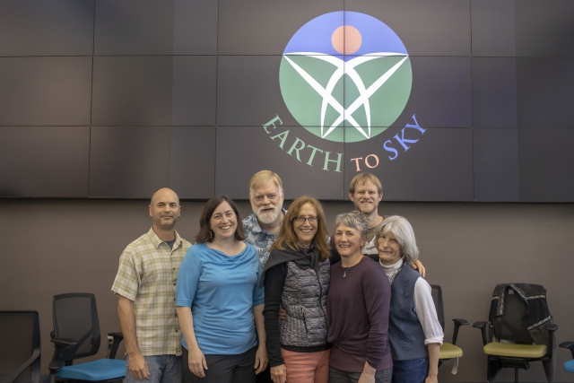
Earth to Sky is an incredible organization built by thousands of like-minded people who have dedicated innumerable hours toward our mission. Today, as we celebrate our 20th Anniversary and look to new horizons, we are honored to reflect on the story of our program.
Our team’s story starts in the age of Space Rangers. Anita Davis began her career at NASA while she was a National Park Service (NPS) Ranger working on detail at the NASA Goddard Space Flight Center, part of a small and historic program informally known as Space Rangers. The Space Rangers were meant to bridge the gap between the work of the National Park Service and NASA, and Anita saw the potential to help interpreters, such as park rangers, use NASA resources in their work with the public. Interpreters are educators who help people connect to stories of the places they love, and NASA’s resources help bring depth to those stories. Some years later, while Anita was working as a contractor at NASA, she met Ruth Paglierani who worked for University of California, Berkeley. The two shared an interest in bringing NASA science to interpreters - the notion that kickstarted the Earth to Sky program.
Over the span of several years, small meetings became larger conferences and visions became reality. In 2004, Ruth and Anita, along with NPS leadership and interpreters, held their first offical Earth to Sky course, training interpreters and informal educators on the breadth of NASA science. When the call went out for coaches to help with this course, Anita and Ruth met a remarkable and influential climate communicator: NPS ranger John Morris. John, Anita, and Ruth became an unstoppable trio who worked to turn their vision into the well-rounded program we know and love today.
As the issue of climate change rose in national attention, the trio realized that NASA’s scientific expertise could lend perspective to interpreters trying to address the topic. It was then that the founders decided that Earth to Sky courses would begin to center around creating excellent climate communicators. John Morris especially helped to champion this topic with a series of historic contributions including the first NPS climate change brochure that printed 500,000 copies to national parks across the country. As important as these brochures became, they almost didn’t make it off the printer—the initial response to the brochure was one of unease, as the NPS had yet to take a public stance on climate change. Still, John persevered, and with the help of NASA scientists who certified the information, the brochures were approved, and helped to open the door for interpreters to start talking about climate change with their visitors.
As a decade of work flew by, Earth to Sky began to attract more partners, including Sandy Spakoff from the U.S. Fish and Wildlife Service, who brought crucial educational methodologies to Earth to Sky. As it became evident that the model was working, and NASA’s science programs were helping interpreters, NASA agreed to fund Earth to Sky, and Anita took the leap to lead the program full time. This funding helped to address to community members' needs, and the regional course model was created, one of our proudest accomplishments.
The regional courses are developed across the country, weaving together NASA and local expertise, and focusing on a specific area's concerns and the interpreters who work there. Meanwhile, Earth to Sky began to build a stronger online infrastructure to organize with a website that provided a place for community members to connect with each other and share resources. With these additions to the program, Earth to Sky began reaching more people across the country, cultivating a wider community from coast to coast, and even Canada's Northwest Territories.
As the program developed, a new opportunity arose to connect people with the wonder of NASA science and outdoor spaces. With the help of NASA's Andrea Jones, and Bryan Mendez from UC Berkeley, Earth to Sky mobilized to help interpreters prepare for the 2017 Total Eclipse, helping to coordinate between agencies, host webinars, and hold a major event at Homestead National Park.
By 2019, the Earth to Sky training methodology had been thoroughly tested and was ready to stretch in new directions. Working with Ruth, John, and new team members Jennetta Giddens and Geneviève de Messières, along with partners from NPS’s Climate Change Response Program, Anita led the development of Earth to Sky’s very first Academy. The Academy would bring a new cohort of experienced and innovative leaders to NASA’s Goddard Space Flight Center in Maryland for a week to train them to develop their own Earth to Sky climate communication courses and nurture regional communiteis of practice inc limate communication.
The participants of this first Academy walked away as Earth to Sky regional leaders, with new tools, a host of new connections, and an enduring sense of hope and community. The Academy also marked a turning point in leadership, as Geneviève assumed leadership of the program, but also as the regional leaders brought new perspectives and wisdom to the trainings. The regional model has since become a staple of Earth to Sky’s efforts, inspiring participants to step into leadership roles and design climate communication trainings rich with NASA resources.
While the COVID-19 pandemic was a difficult time for the Earth to Sky community, it provided new opportunities to connect virtually. John developed a plan for online conversations that would bring interpreters and informal educators together to support each other during this time. This series evolved into the current lively Climate Conversations monthly program, which is paired with the monthly Climate in Your Pocket webinar series.
In the last few years, the program has expanded at an electrifying rate. NASA’s Earth Science Division and the NASA Science Activation Program provided a budget increase, which allowed Earth to Sky to hire on four more full-time members who bring passion and experience to the team. The program continues to innovate and push its model to greater heights by hosting exhibits at conferences, organizing eclipse efforts, launching a virtual course, working with our partners, leading regional courses, bringing on cohorts of interns, and recruiting new regional teams.
After 20 years, Earth to Sky remains a shining example of the power of connection. Our organization exists today because of the endless dedication that our community members and partners have extended to Earth to Sky in the name of creating better interpretation and education programs for their audiences. It is because of our community that the vision Anita, Ruth, and John had has been realized in more ways than they ever imagined. We are immensely grateful for every member of this community, past, present, and future, and we hope to keep making “space” (get it?) for more passionate people in our community. Thank you for being here. Ad astra!
Read testimonials from Earth to Sky's 20 years of history here!