Regional Downscaling
Relating global climate change projections to regional, or even local, effects is critical for making policy and investment choices that can reduce the potential for future adverse climate impacts. However, it is not simply a matter of running a global climate model and looking at the results at a specific location.
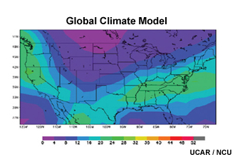
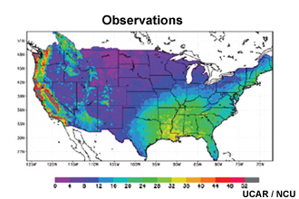
While global models are useful for understanding broad features of climate change, their resolution is too coarse to answer questions about smaller regions. In other words, the points at which a global model makes calculations are too far apart to see topographical features that often determine the finer structures in weather patterns. So, for example, the model results (top image) get the broad features correct, but miss many details that show up in the observations (bottom image). This is particularly true in the western U.S. where there is more varied topography. Global climate models can also miss other influences, such as those caused by the interface between sea and land.
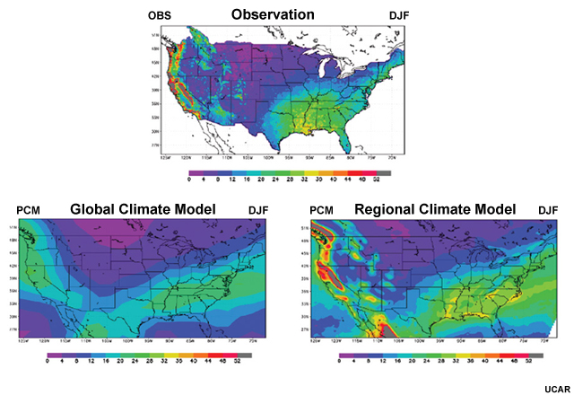
A technique known as "downscaling" takes global model output and uses it to provide information closer to the local level. Scientists use two basic methods: dynamical downscaling and statistical downscaling. So, in this example, a regional climate model (an example of dynamical downscaling) gives results that produce more realistic local-scale features that better replicate the observations.
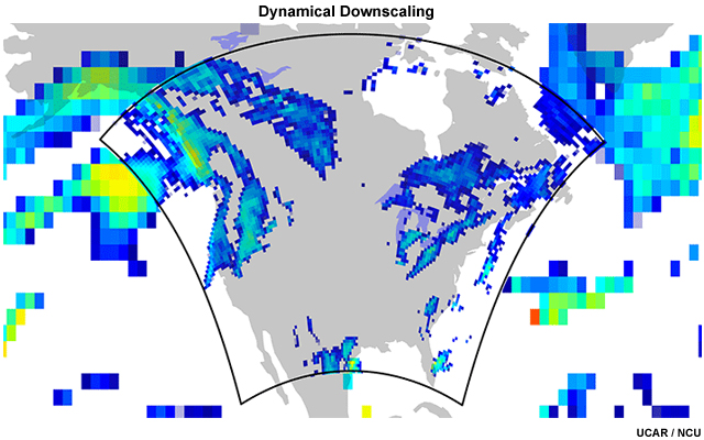
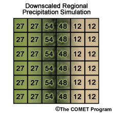
In dynamical downscaling, scientists nest a regional climate model (shown in the center of this figure) within the output of a larger global-scale climate model (indicated by the larger pixels on the edges). The nested regional climate model takes meteorological, oceanic, and land-surface data generated by the global climate model and makes a regional projection. Because regional models have a more limited scale, they can be run at much higher resolution (as shown by the smaller pixel sizes) than can be achieved by global models.
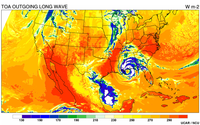
Nested regional climate models are improving every year and can even produce realistic depictions of weather features, such as this simulation of a possible future hurricane hitting the Gulf Coast. Some researchers downscale the results further by also using "weather-scale" models that can simulate individual storms. While these results are not intended as forecasts years in the future on a specific day, the models' ability to produce realistic weather indicates they can simulate features that affect broader weather patterns. Researchers then use simulations of specific events to establish statistical trends in such things as frequency of hurricanes per year over a multi-decadal period.
However, dynamical downscaling has its challenges. For example, small errors in the global climate model may amplify inside the nested domain and become major errors. Another weakness is the lack of productive cross-talk between the regional climate model and the global one. The regional model can theoretically provide the global one with feedback, increasing overall accuracy, but this also increases the computing requirement substantially.
The second approach, statistical downscaling, takes advantage of statistical relationships between regional climate and global climate. That is, scientists may notice that when the global climate does A, the regional climate responds by doing B some percentage of the time.
By developing a long list of such statistical associations, scientists can input the conditions projected by global models into regional statistical downscaling systems to predict how the regional climates will respond to future global temperatures or greenhouse gas concentrations.